
Projects
 Click here to view Geological Report
 Click here to view Technical Report
Sunnyside/Patagonia
The following data is Non 43-101 compliant
The company is currently focused on its 100% owned flagship copper exploration project, the Sunnyside property, located near Nogales, Arizona.
Overview
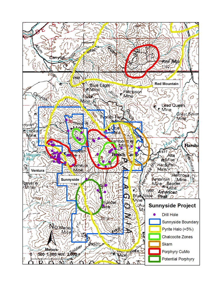
The Sunnyside property is located near Nogales, Arizona about 72 kilometers south of Tucson in the prolific Laramide porphyry copper province. Sunnyside is situated along the trend of the Cananea Mine to the south and the Mission Complex to the north.
The property consists of 295 claims totaling approximately 5,900 acres (22km2 ) containing several areas with drilling completed by ASARCO, Anaconda and others. Four main targets (and several secondary targets) were identified by geologic mapping and core drilling conducted from 1952 through 1992. The main targets are:
- Sunnyside Deep
- Sunnyside Shallow
- Chalcocite Enrichment Zone
- Sunnyside Skarn
History & Development
In the past years from 1850s to 1990s, there have been a few mines produced here. They vary from 320 tonnes to 850, 000 tonnes of production in sizes (see table 1)
Table 1 Past production in the surrounding area
| Old Mine | Year of Production | Production (t) | Cu (grade) | Pb (grade) | Zn (grade) | Ag (grade) g/t | Mn (grade) | Au (grade) g/t |
|---|---|---|---|---|---|---|---|---|
| Flux | 1850-1963 | 850,000 | 2.5% | 5% | 8% | 155.5 | 2.5% | |
| 3R | 1908-1956 | 130,000 | 4% | |||||
| Worlds Fair | 1880-1954 | 13,000 | 0.7% | 6.6% | 1803.8 | |||
| Sunnyside | 1890-1953 | 1,600 | 8% | 49.76 | ||||
| Humbolt | 1880-1952 | 1,200 | 1% | 7% | 1.5% | 590.9 | ||
| European | 1913-1929 | 320 | 10% | 124.4 | 3.11 | |||
| Ventura | 1933-1950 | 440 | 6% | 1% | 497.60 | 6.22 | ||
| Trench | 1850-1890 1918-1945 | 237,000 | 8.5% | 6.3% | 404.3 | |||
| Blue Nose | 1880-1956 | 13,000 | 0.5% | 2% | 1% | 559.8 |
Geology
Regional Geology
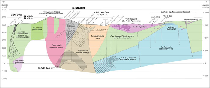
The Sunnyside Project is situated in a broad northwest trending corridor of porphyry copper deposits that straddles the U.S. -- Mexico border. This corridor is defined by many deposits from Groupo Mexico's La Caridad mine located in central Sonora, Mexico, through to Mercator Mineral's Mineral Park mine located in northwestern Arizona. Geographically (and geologically), the Sunnyside Project is located in southern Arizona within the Basin and Range province that covers most of the southwest United States and northwestern Mexico. The Basin and Range province is characterized by linear mountain chains separated by broad flat valleys that have resulted from tectonic extension that began some 17 million years ago in the Miocene.
The Project is located in the Patagonia Range of mountains approximately 25km northeast of Nogales, AZ. The range is cored by a Laramide, multi-phase intrusive complex comprising quartz monzonite to granodiorite and lesser quartz-feldspar porphyry. Radiometric age dates completed by the USGS and others (Graybeal, 2007) suggest the emplacement of the intrusive occurred between 74 and 58 Ma. As is typical of the Basin and Range region, where normal faulting often results in the juxtaposition of differently aged rocks, there is a fault zone along the Patagonia Range that causes Proterozoic crystalline rocks to crop out along the western range front whereas the eastern part of the range exposes complexly faulted Paleozoic to Mesozoic sedimentary and volcanic rocks. The Laramide intrusions fill the divide between the Precambrian and Paleozoic rocks. Younger Cenozoic-age volcanics were deposited over the northern portion of the range and are likely related to the extension that resulted in the development of the Basin and Range physiography.
Property Geology
As described above, the oldest rocks in the area occur along the western edge of the property. These rocks include a package of Proterozoic crystalline rocks described as meta-intrusive to meta-sediments. Along the eastern border of the project area Cretaceous sediments and volcanics overlay Paleozoic limestone and shale. Drilling has indicated apparently complex folding and faulting within the Paleozoic and Cretaceous rocks that is likely related to Laramide tectonics.
The central portion of the project area is composed of multiple phases of Laramide-age intrusive. The intrusive is composed of granodiorite to quartz monzonite with several quartz-feldspar-porphyry (QFP) intrusions. The Laramide intrusions now occupy a significant structural zone between the Precambrian rocks on the west and the Paleozoic-Cenozoic rocks on the east.
Covering the intrusive to the south, north and east are wide spread Tertiary volcanic and volcanoclastic material described as a lapilli tuff. This material is believed to be contemporaneous with the intrusive activity and derived from the same material. Much of the rock is highly altered with textures nearly completely replaced by pyrophyllite and silica where it overlies the mineralized intrusive at depth. The lapilli tuff was formed concurrent with the Sunnyside intrusive event. This event formed a circular feature approximately one mile in diameter and further described as a diatreme. The lapilli tuff and associated maar deposits filled the diatreme and breached the northeastern diatreme boundary. The lapilli tuff is believed to be derived from numerous cycles of pyroclastic eruptions and attendant intrusions.
Mineralization
It was apparent that a significant hydrothermal system is exposed at surface at the Sunnyside Property. The Sunnyside Project exhibits a very complex pattern of intrusive rocks that represent multiple phases of intrusive activity. Along with several of these phases of intrusion have come different phases of alteration and/or mineralization. However, the most intense alteration observed at surface appears to be focused around quartz-feldspar porphyry (QFP) intrusions. The QFP bodies appear to have been instrumental in the formation of an approximate 1.5km diameter diatreme overlying the deep porphyry copper system. The diatreme is composed of milled rock that has been described as lapilli tuff. Within the boundary of the diatreme several QFP outcrops present themselves as extrusive flow domes. The lapilli tuff and associated maar are extensively altered to an advanced argillic assemblage containing enargite, covellite and chalcocite. From historical drilling, the advanced argillic alteration grades downward into phyllic and then potassic alteration assemblages containing chalcopyrite and molybdenite. An alteration map of the property was compiled by Graybeal (1975) from several historical exploration programs.
The mineralization occurring within the project boundaries has been explored by various companies (Asarco, Kerr McGee, Anaconda, etc.) and has been studied by the U.S.Geological Survey (Vickre, et al. 2009 and Graybeal and Vikre, 2010) sporadically over the last forty years. The multi-phase intrusive core of the Patagonia Range in the area of the Property appears to have developed adjacent to/along a long-lived fault zone (Guajalote Fault). Vickre (2009) reports that at least six intrusive events occurred within the Patagonia Mountains over a period of 16 million years. The QFP stocks of Sunnyside intruded between 61 and 58 Ma (Graybeal, 2007, Vickre et al, 2009). Individual alteration areas overlap. All of the historical work has identified alteration and mineralization at Sunnyside that is consistent with the classic vertically and concentrically zoned porphyry copper system.
As a result of Regal's recent work to compile and re-evaluate all of the historical work completed at the Property, a number of discreet targets have been identified. The primary focus is obviously on the identification of porphyry copper (+/- molybdenum) mineralization. The main porphyry target comprises the deep porphyry system identified in historical drilling. However, recent mapping and analysis of new data generated from the examination of the historical drill core has identified a potential for identifying porphyry copper mineralization closer to surface in the vicinity (and likely west of) drillhole TR-11. In addition to the main porphyry targets, there is a potential for identifying significant copper mineralization in chalcocite enrichment zones located relatively near surface, which may represent the result of oxidation of potential shallow mineralization associated with porphyry and/or breccias systems. Finally, there is a potential for identifying significant base-metal skarn mineralization adjacent to the main porphyry system in calcareous Paleozoic rocks.
Exploration
Regal Resources has been active on the Sunnyside Project since its acquisition in 2010. Regal's exploration efforts have focused on data compilation and confirmation and target evaluation. Data compilation included acquiring and digitizing surface geochemical data including rock chip samples from the files of the U.S. Bureau of Mines (Chatman, 1994), the Arizona Department of Mines and Mineral Resources, and historical exploration reports (largely unpublished) produced by companies such as ASARCO, Anaconda, Kerr- McGee, West Range (now Xstrata) and Rio Algom. More importantly, Regal has located and acquired a considerable amount of the drill core that remains from historical drilling completed at the project. This compilation effort, which included the re-logging and sampling of many of these drill cores, has confirmed historical findings and provided additional data that has allowed for the refinement of the geological model at Sunnyside and the mineralization targets that are discussed in the Conclusions and Recommendations sections of the NI 43-101 report as the focus for future exploration at the Project.
Historical Drill Core and Drill Data
Regal has located and acquired a considerable amount of the drill core that remains from historical drilling completed at the project. A detailed program of cataloguing, logging (re-logging), photographing, and re-assaying of the available historic drill core was completed during the first half of 2011. Logging and reinterpretation of the previous drilling has confirmed and refined the target concepts being advanced by Regal. Regal Resources has (re-) logged five (5) "deep" core holes and 12 shallower core holes at Sunnyside to evaluate lithologies, alteration and mineralization within the system. Along with the re-logging of the five (5) deeper and 12 shallower historical drillholes completed on the Property, Regal has evaluated drill logs and core from 8(+) other historical drillholes. The re-logging and evaluation of the 5 deeper historical drillholes, in particular, has provided a consistent nomenclature that has been applied to the other historical drillholes, all of which were the result of multiple drilling (and logging) programs completed by different workers and were difficult to compile previously without this common framework. This is the most significant outcome from the recent work completed by MinQuest on behalf of Regal and has resulted in an interpretive cross section that illustrates the geological potential of the Property and provides an excellent geological model for the Property that can be used as a guide for future exploration.
Geochemically, Regal selected 78 samples from historic core holes drilled within the chalcocite target area for resampling and reassay. The core holes (BB 2, 3, 4 and 6) are located in the northeastern portion of the project area. Samples were collected from core along the same intervals as historic assays. The new samples were submitted to Skyline Labs in Tucson, Arizona. The historic core sampling results of the Chalcocite Target were confirmed by the recent reassays conducted by Regal indicating significant intervals of copper and silver mineralization. A summary of selected portions of Regal's re-assay program is provided below in Tables 2 and 3. More detailed results of the re-assay program are provided in Appendices in NI 43-101 report.
Table 2 Sunnyside Chalcocite Target Confirmation Analyses
| Hole ID | From | To | Interval | Cu (%) | Ag (g/t) | ||
|---|---|---|---|---|---|---|---|
| (m) | (m) | (m) | (Historical) | (Regal) | (Historical) | (Regal) | |
| BB - 2 | 12.20 | 42.68 | 30.48 | 0.47 | 0.45 | 2.2 | 4.4 |
| BB - 3 | 4.27 | 27.44 | 23.17 | 0.60 | 0.27 | 0.8 | 4.9 |
| BB - 3 | 182.93 | 219.51 | 36.58 | 0.32 | 0.32 | 2.0 | 3.2 |
| BB - 4 | 3.90 | 57.93 | 54.03 | 0.46 | 0.45 | 2.1 | 3.6 |
| BB - 6 | 6.10 | 36.59 | 30.49 | 0.32 | 0.34 | 4.2 | 8.6 |
| BB - 6 | 91.46 | 149.39 | 57.93 | 0.64 | 0.82 | 4.6 | 12.8 |
Additional sampling conducted by Regal tested additional samples of the chalcocite and skarn targets along with the deep porphyry target and resulted in the collection of a further 183 samples of core from drillholes TCH2, TCH-2A, TM-13 and TM-14, 78 of which comprised samples of previously unsampled core. In summary, these samples confirmed and added to historical intersections. In addition to the Cu and Ag values summarized above, the recent resampling of some historic drilling and surface samples indicate potential for low grade rare earth, rhenium and bismuth mineralization. Lanthanide elements are enriched in several areas of drilling and are occasionally present in surface sampling. Although poorly understood, these elements should be further studied for near surface potential. Bismuth is intimately associated with the massive sulfide portion of the skarn and should be evaluated in future drill programs. Rhenium values are intimately associated with molybdenum within the porphyry and skarn alteration.
Table 3. Sunnyside Skarn Target Confirmation Analyses.
| Hole ID | From (m) | To (m) | Interval (m) | Cu (%) | Pb (%) | Zn (%) | Ag (g/ton) | Source |
|---|---|---|---|---|---|---|---|---|
| TCH-2 | 1418.25 | 1435.63 | 17.37 (57ft) | 1.20 | 4.97 | 12.15 | 342.10 | ASARCO Historic |
| 1.17 | 4.27 | 10.70 | 306.65 | REGAL (new) | ||||
| 1453.00 | 1490.79 | 37.79 (124ft) | 0.23 | 0.98 | 14.08 | 228.90 | ASARCO - Historic | |
| 0.23 | 0.91 | 13.58 | 228.90 | REGAL (new) | ||||
| TCH-2A | 1255.79 | 1267.98 | 12.19 (40ft) | 1.48 | 0.30 | 0.60 | 68.42 | ASARCO - Historic |
| 1.42 | 0.26 | 0.58 | 74.95 | REGAL (new) |
Program
The results generated by the data compilation and historical drill core re-logging and sampling program recently completed by Regal at the Sunnyside Project are sufficiently encouraging to warrant a significant exploration program. Furthermore, the extent and degree of alteration observed in outcrops at the Property clearly indicates that a significant hydrothermal system has affected the rocks underlying the Property.
The Sunnyside Property hosts compelling shallow (within ~1000m of surface) and deep (below ~1000m of surface) Porphyry Cu-Mo targets. In addition, the Property hosts shallow Cu (+/- Ag) targets comprising mineralization associate with chalcocite enrichment zones and abundant breccia pipe systems, the latter having been mapped throughout the Property. Finally, base metal skarn mineralization has been intersected in several deep drillholes located on the northeastern portion of the Property.
In the opinion of Mr. Andrew Turner, the author of NI 43-101 report for Regal's Sunnyside Project, the Cu-Mo porphyry and Cu-Ag breccia and chalcocite targets are the most compelling and warrant further exploration. A phased exploration program is recommended. The Phase 1 exploration program would comprise a large soil sampling and ground geophysical program intended to examine the potential for identifying Cu (+/-Ag) mineralization associated with relatively shallow level breccias and/or chalcocite enrichment zones and the shallow Cu porphyry target. A large array (deeper penetrating) IP (Induced Polarization) survey is also recommended as part of the Phase 1 exploration program. IP geophysical surveying is a technique that is commonly applied to the exploration of porphyry Cu systems due to its ability to highlight disseminated sulphide minerals associated with this deposit model.
Modern survey systems, such as the Titan 24 system used by Quantec Geoscience, have the benefit of being able to penetrate to, and generate data from, significant depths and may even be able to provide information applicable to the targeting of the deep porphyry target at the Property. This is the primary reason for phasing the recommended exploration program as this will allow for the completion of such a deep-penetrating geophysical survey that may provide information to assist in the targeting of drilling to test the deep porphyry Cu target at the Property Drill testing of shallow breccia zone, chalcocite and porphyry targets, along with drill testing of the deep porphyry target, comprise the second phase of the recommended exploration program at the property.
Obviously, the lower cost of conducting shallow drilling, combined with the benefits of identifying a potentially open-pitable resource at the property, would lead one to prioritize this effort over deeper drilling. However, a limited deep drilling program is recommended based on the fact that historical drillholes have already identified porphyry copper mineralization at the deep target and thus there exists a significant potential for identifying a potentially economic deposit analogous to that at the Resolution Cu Project, for example, located near Superior, AZ.
The following is a summary of the work program and their costs
Phase 1: Soil sampling and geophysical surveying (US$300,000);
Phase 2: Drilling (US$2,200,000);
Total: US $ 2,500,000
All of the work items listed above are considered to be warranted at this time and none are contingent on the results of any of the others. The porphyry, chalcocite and skarn targets are defined sufficiently at this time to allow for further drill testing. The geophysical and geochemical surveys comprising the Phase 1 program are intended to explore for additional targets on the Property and refine the targeting for a Phase 2 drill program.


